USGS scientists recently began to examine new hypotheses for mineral deposit occurrences.

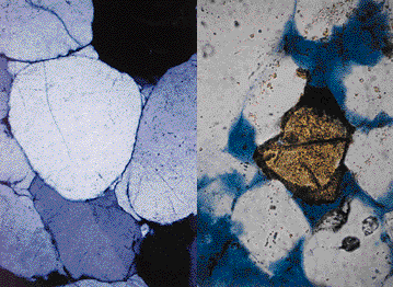 The conventional hypothesis for formation of lead-zinc deposits in the Mississippi Valley district states that ground-water fluids move under the influence of gravity from their original sites to deposit sites. This simple gravity-flow model is challenged by new geological observations such as unfavorable porosity and permeability, lack of evidence of movement of hot fluids over very long distances in conduit rocks in key zones, and by the role of extensive deep faulting in the basin. An alternative model suggests that thermal convection related to heat conducted along deep faults may explain more geological constraints than would a gravity-driven flow model. USGS researchers presently are testing these competing models and their applicability to finding new lead-zinc deposits.
USGS scientists show that revised depositional models for rock units is the key to a better understanding of the geometry of reservoir and conduit rocks.
A detailed analysis of rock units that have the potential to be reservoirs or conduits for fluids indicates that continuity, and hence porosity and permeability, is more variable than previously thought. This is important not only for hydrocarbon exploration but also for mineral deposit modeling, waste disposal, and gas storage strategies. For example, recent data suggest that one crucial horizon contains a sandstone that occurs largely in valleys created by erosion millions of years ago. These valleys, now at depths ranging from 800 feet to 2,500 feet, are filled with sand that is a potential reservoir. Techniques used to understand the lateral and vertical variability in porosity and permeability within the framework of these potential reservoir or conduit rocks are being applied to other critical horizons. This information can then be used by public- and private-sector interests for decision-making regarding exploration, waste and storage management, and recovery strategies.
 USGS researchers have recently acquired seismic data that bear on analysis of basin-wide geologic hazards and hydrocarbon exploration.
In particular, USGS scientists are concerned about recent earthquake activity in the eastern area of the basin along the Wabash Valley fault system. In 1987, this fault system experienced a 5.0-magnitude earthquake. The well-known and seismically-active New Madrid fault zone extends southwest from the basin, and it is possible that active faults in the vicinity of the Illinois Basin may be controlled by similar processes acting at great depth below the Earth's crust. New seismic data will provide greater detail of the basin's structure, and may provide clues to future seismic activity within the basin or at its margins. Seismic data, in conjunction with a new understanding of the thermal history of the basin, may also help explain why petroleum exploration south of the 38th parallel has been unsuccessful. Evaluation of seismic data may help to identify potential new targets for hydrocarbon exploration where existing deep drilling is sparse or absent.
For More Information:
Dr. Jennie Ridgley
U.S. Geological Survey
MS 939
Box 25046
Denver Federal Center
Denver, CO 80225
(303) 236-9048
 "In well-explored areas such as the Illinois Basin, the large lead-zinc-fluorite and fossil-fuel deposits have already been found; simple models of their deposition and occurrence no longer apply very well to locating new deposits. The challenge we face today in the discovery of new deposits and in the extension of known deposits is to apply new technology and advanced concepts
through multidisciplinary team efforts."
"In well-explored areas such as the Illinois Basin, the large lead-zinc-fluorite and fossil-fuel deposits have already been found; simple models of their deposition and occurrence no longer apply very well to locating new deposits. The challenge we face today in the discovery of new deposits and in the extension of known deposits is to apply new technology and advanced concepts
through multidisciplinary team efforts."
